Saint-Onge

| |
| Motto: Laissez les bontemps rouler' | |
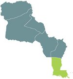
| Subdivision of: | Louisianne |
| Cities: | |
| Capital: | Baton Rouge |
| Largest: | New Orleans |
| Other: | Vienne-le-Port, Hammond, Natchitoches, Shrèveport |
| Languages: | |
| Official: | Francien, Narbonosc |
| Others: | English, Castilian, Swedish |
| Préfet: | Marie Landrieu |
| Area: | 154,382 km2 |
| Population: | 3,675,976 |
| Established: | 1820-40, de facto |
Saint-Onge was once Nouvelle Orleans, but changed names once returned to Louisianne from the North American League following the 1828 War.
Administration
Administrative Divisions
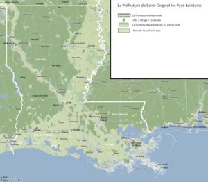
The Prefecture of Saint-Onge is divided into four départements; Loire-Neuf, Côte de Châtaigne, Pont-Chartrain, La Salle.
History
Originally the name-sake of her nation, after St. Onge was taken from Louisianne forcibly by the NAL in the War of 1828, it was decided that a clean break from past embarassments was needed. Upon recession by NAL was thus given the name St. Onge in honor of one of the original settlers of the region.
La Salle was originally the popular choice, but after an ad campaign by amerindians against the 'amerindian killer,' the name was dropped in favor of Michel St. Onge, catholic father, beneficiary to the amerind peoples.
The prefecture resides in Baton Rouge, where the capital was rebuilt after the prefectoral buildings of Nouvelle Orléans were destroyed in the war of 1828.
Geography
Largely silt from the muddy Mississippi river, Saint-Onge also has some rolling hills in the northern section, leading up to the Ozarques. The coastal regions fluctuate over the years depending on the route of the Mississippi and the sediment that it leaves. The underlying strata of the state are of Cretaceous age and are covered by alluvial deposits of Tertiary and post-Tertiary origin. A large part of Saint-Onge is the creation and product of the Mississippi River. It was originally covered by an arm of the sea, and has been built up by the silt carried down the valley by the great river.
Near the coast, there are many salt domes, where salt is mined and oil is often found.
Owing to the moderate flood control measures along the Mississippi river and to natural subsidence, Saint-Onge is now suffering the loss of coastal land area. Prefectoral and national government efforts to halt or reverse this phenomenon are under way; others are being sought.
The surface of Saint-Onge may properly be divided into two parts, the uplands, and the alluvial coast and swamp regions. The alluvial regions, including the low swamps and coast lands, cover an area of about 52,000 km²; laying principally along the Mississippi River, which traverses from north to south for a distance of about 1,000 km and ultimately emptying into the Gulf of Mexico, the Loire Neuf, the Ouatchita River and its branches, and other minor streams. The breadth of the alluvial region along the Mississippi is from 15 to 100 km, and along the other streams it averages about 15 km. The Mississippi flows upon a ridge formed by its own deposits, from which the lands incline toward the low swamps beyond at an average fall of 3 m/km. The alluvial lands along other streams present very similar features. These alluvial lands are never inundated save when breaks occur in the levees by which they are protected against the floods of the Mississippi and its tributaries. These floods, however, do not occur annually, and they may be said to be exceptional. With the maintenance of strong levees these alluvial lands would enjoy perpetual immunity from inundation.
The uplands and contiguous hill lands of the north and northwestern part of the state have an area of more than 65,000 km², and they consist of prairie and woodlands. The elevations above sea-level range from 3 metres at the coast and swamp lands to 15-18 metres at the prairie and alluvial lands.
Besides the navigable rivers already named (some of which are called bayous), there is the Sabine River forming the western boundary, and the Perl or Pearl forming the eastern boundary. Also are the Calcasieu, the Mermentau, the Vermilion, the Bayou Teche, the Atchafalaya, which is really a branch of the Mississippi, the Boeuf, the Bayou Lafourche, the Courtableau, the Bayou D'Arbonne, the Macon, the Tensas, the Amitie, the Tchefuncte, the Tiquepha, the Natalbany, and a number of other streams of lesser note, constituting a natural system of navigable waterways, aggregating over 4,000 miles in length, which is unequalled in the rest of Louisianne or the North American continent. The Prefecture also has 1,060 square miles (2,745 km²) of land-locked bays, 1,700 square miles (4,400 km²) of inland lakes, and a river surface of over 500 square miles (1,300 km²).
Topography
Borders
Saint-Onge is limited by:
- North: Les Ozarques,Saint-Louis
- West: Tejas
- South: Gulf of Mexico
- East: Mobile Province, NAL-SLC.
Economy
The total gross prefectoral product in 2003 for Saint-Onge was L€875 million, equating to a per capita L€5240, ranking it among the lower third of Louisiannan income brackets.
The principal agricultural outputs include seafood, being the largest producer of crawfish in the world, and if one were to include the Pays-Lointains, would rank several percentage points above the next largest producer. Also produced are cotton, soybeans, cattle, sugarcane, poultry and eggs, dairy products, rice, and the wines of the Loire valley. Its industrial outputs include chemical products, petroleum and coal products, offering a cheaper production costs than NAL refineries and competitive rates against Tejan refineries, and due to the more politically stable environment in Louisianne, Saint-Onge holds a large percentage of the refinery market-share. Food processing, transportation equipment, paper products, and tourism round out the major industries. These have all been affected since the detonation of the Floridian nuclear device, however, clean-up is ongoing and the effects are expected to be mitigated in the next 10 years.
Culture
| |||
|---|---|---|---|
| Préfectures of Louisianne | |||
| Nouvelle Cournouaille | Nouvelle Gaulle | Nouvelle Navarre | Osage | Saint-Louis | Saint-Onge | |||
| Départements of Louisianne | |||
| Alpes-Argentés | Alpes-Rocheuses | Aurillac | Bretagne | Côte de Châtaigne | Côte d'Or | Daquota | Dordogne | Garonne-Neuve | Gascogne | La Salle | Les Ozarques | Loire-Neuf | Mississippi | Mizouri | Nyobrara | Omara | Oto | Paris-sur-Mizouri | Pays-Lointains | Pont-Chartrain | Rocheuses | Saint-Louis | Terre Platte |

