Daquota
From IBWiki
Jump to navigationJump to search
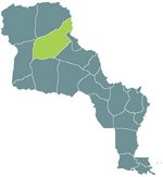
Named after the Daquota indians who inhabited the region across the river in Les Plaines, the Département of Daquota has the highest native population in the nation of Louisianne. It was the latest addition to Nouvelle Cournouaille, and home to much wheat farming and roving herds of American Bison that cause much trouble with farmers.
A common misconception that the natives are all of the Daquota tribe is earnestly protested at all opportunities by the local Laquota.
Economy
The Dakota Tribe have recently begun mining in earnest in the Noirraines and are building up that industry.
| |||
|---|---|---|---|
| Préfectures of Louisianne | |||
| Nouvelle Cournouaille | Nouvelle Gaulle | Nouvelle Navarre | Osage | Saint-Louis | Saint-Onge | |||
| Départements of Louisianne | |||
| Alpes-Argentés | Alpes-Rocheuses | Aurillac | Bretagne | Côte de Châtaigne | Côte d'Or | Daquota | Dordogne | Garonne-Neuve | Gascogne | La Salle | Les Ozarques | Loire-Neuf | Mississippi | Mizouri | Nyobrara | Omara | Oto | Paris-sur-Mizouri | Pays-Lointains | Pont-Chartrain | Rocheuses | Saint-Louis | Terre Platte |
