Four Nations
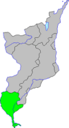
A small fithing in the narrow stretch of land between the Mississippi and Illinoise Rivers. It was established by French, English, Irish, and Scots who moved into the vacant land following the fall of the Illini confederacy. By the 1820s the region was a sort of no-man's land between the colonial powers, and the settlers it attracted enjoyed not being tied to any external authority. They resisted both pressure from Louisianne and absorption into the English loyalist settlements that would develop into Illinoise province. This attitude helped the settlers mix relatively well; the majority supported the Natives to the north in Black Hawk's new province.
From early on, however, it was a challenge to establish a government that could effectively administer Four Nations' diversity. With nothing to unite them after the threat of external annexation had passed, the people of the fithing frequently revolted against their elected officials, sometimes peacefully, sometimes not. As new immigrants arrived from parts of the NAL to the east and south, things began to calm down in Four Nations. However, the authorities continued to be challenged by an ingrained attitude of disrespect for laws, including laws banning slavery.
Four Nations is administered from the city of Lustbader (*here*'s Quincy, Illinois). It was founded by Jan Van den Houten, a pioneer from the Mohawk Dutch hybrid culture in the Nieuw Batavie / Aquonishuonigy border regions. Van den Houten, a future Lord Governor of the province, saw the advantages of the site, on bluffs overlooking the Mississippi, and bought the property, divided into lots, and sold to people looking to live in the new town. Originally named Bluffs and nicknamed "Jansbrug", in 1831 the town was named for Martin van Lustbader, General Moderator of the NAL during the 1828 War. The choice of name reflected both Van den Houten's and the townsfolk's wish to join the NAL during the contentious period before provincehood. The name also represented their opposition to slavery, which GM Lustbander shared.
The southern end of Four Nations tapers to a long, narrow tail of land between the two rivers. Known as La Queue, the region is the most French-speaking part of Ouisconsin.
At the very tip of La Queue is the town of Alton. Alton is a suburb of Saint-Louis, Louisianne, and is Four Nations' largest city. Alton *there* is in a different location from the town of the same name *here*: the town *there* is in the wedge of land between the Mississippi and Missouri Rivers, the only part of Ouisconsin on the other side of the Muddy Mississippi, and the only part to border Louisianne. [1]
Alton is a bedroom community for St. Louis, as a number of residents work in Louisianne. Citizens living on the NAL side of the border with Louisianne are able to take advantage of the lower prices and taxes on goods. In accordance with trade agreements between the NAL and LA, which uses the "metric system", all export quality goods are marked in both metric and SI units for ease of international trade. Alton is also a major rail hub for trains between the two countries: the Louisiannais CFL passes through Alton, as do the Mississippi & Western Railroad and the Baltimore and Aquonishuonigy.
Towns
- Alton:
- East Saint-Louis (Saint-Louis de l'Est)
- Lustbader:
- Nowy Veneda (here's Radom, IL): founded by Venedic noblemen in 1830 at the behest of Polish explorer, merchant, polyglot, and ally to the Potawatomi, Anton Sadowski. Sadowski laid claim to the area in 1818 and sent word back home to the Republic of Two Crowns to entice his countrymen to move to such a fertile area free from political repression. A small core of overly-idealistic noblemen funded it and had vague ideas of returning to the soil in free America, but it turned into the noble stockholders doing nothing while the peasants they brought with doing all the work in a sort of patroon system identical to the system found in Nieuw Nederland. There was probably a higher than usual mortality rate due to mismanagement of the colony at the hands of the nobility turned gentlemen farmers. Those toiling peasants eventually overthrew their leaders and spread out in the area, with most ending up as bedraggled refugees in Saint-Louis. “New Veneda” is still a town, but no one speaks it there anymore. Those that stood their ground and remained in the settlement were some of the first to join the NAL's nascent socialist movement and their anticlerical attitude lead them to declaring the token Catholic chapel built for them on Warsaw's orders for the Presbyterian church, which has not such a rigid notion of a priesthood as the Catholic institution. Venedic culture was kept alive in Chicago, not out in the vast prairie farmland of the test of Ouisconsin. The lone church in town still has a service in Wenedyk once a month for thew few elderly churchgoers left in the small hamlet.
| |||
|---|---|---|---|
| Fithings | |||
| Kiwikapawa | Ho-Chunk | Othaaki-Meskwaki | Bodewadmi | Four Nations | |||
| Cities | |||
| St. Francis | Chicago | Milwaukee | Creve Coeur |
Notes
- [1] This is an attempt to coordinate various QSS bits about Ouisconsin's borders. I'll provide a more detailed explanation if needed.
