Talk:South America
Takeover? No! Update!
Yes, I know this page is lopsided, but since I have "taken over" ;-) the Lusoamerican Union I had to update the member states. Kyrmse 14:10, 14 Jul 2005 (PDT)
Flags & Names on the Map
Chlewey: Please take a look at this map and tell me whether I've got anything wrong. Note that it is a low-quality .jpg; it will become a much better .png once discussion is finished.
I had three difficulties:
- The location of Kemrese Guyana is nowhere defined, so it is not on the map;
- I had no Paraguayan flag (by you) to go by, so I took a flag of Paraguay *here* and removed the central badge;
- Batavian Guyana has no flag either.
[ Image has been removed - see below for updated version ]
I case you're wondering why I changed the flag of Paraná: Paraná *here* happens to be my home state, so I decided the flag should have the diagonal stripe and a circle in the centre. The colours of Estado do Paraná are green and white, so I used these - and red from the flag of Estado de São Paulo, where the capital of Paraná *there* is located. Your flag looked too much like that of Estado do Rio Grande do Sul, not representative of the whole - and too far at the southern corner. I hope you don't disagree too much. Kyrmse 13:21, 20 Jul 2005 (PDT)
- Batavian Guyana does have a flag now. In fact, it has had a flag all the time. I thought it was on FOIB? --IJzeren Jan 12:25, 21 Jul 2005 (PDT)
- Chlewey: Ya tenemos Kemrese Guyana? Kyrmse 17:07, 21 Jul 2005 (PDT)
- Sí, la Guyana Cámbrica y la Guyana Inglesa deben repartirse el territorio de Guyana *aquí*. Una propuesta: Guyana Cámbrica ocupa el actual territorio de Essequibo (el territorio al oeste del río Essequibo, reclamado *aquí* por Venezuela) y la Guyana Inglesa incluye el territorio al este (incluyendo Georgetown) y alguna parte de Suriname (hasta Wageningen).
- Kemrese Guyana and English Guyana should share the territory of *here*'s Guyana. A proposal: Kemrese Guyana would include the Essequibo territory (territories west of Essequibo), while the English has the East terrotories and a little bit of Suriname (to Wageningen or so).
- So, basically, the English territory is the old territories of Essequibo and Demarara and a little slice into Batavian Guyana. I can live with that, or even without the little slice into Batavian Guyana. If I can find a decent map of Guyana's innards, I'll work on a map of the British Guyanas. Elemtilas
- I've placed an updated map, "map_south_america_2005.bmp", in the IB files section of Conculture. Also, I think the generic English territorial flag should be replaced with the English Guyana flag. Elemtilas
- The map seems okay to me. You should probably whiten a little more the sea so that the Samonios Islands flag would contrast a little, even with fimbriation. Probably something like the square at the right.
- I have no objections against a piece of Batavian Guyana being stripped off in favour of a Kemrese Guyana. But it better be not too much: otherwise we wouldn't have sold New Castreleon to the British in return for it! :)
- By the way, I vaguely recall that Kemrese Guyana also included part of Venezuela. Or is that nonsense?
- Last question: why would Batavian Guyana have 8 million inhabitants? *Here*, Suriname has less than half a million. Even the absence of the December murders won't explain such a difference!
- --IJzeren Jan 09:29, 22 Jul 2005 (PDT)
- Below is the current version of the Map of South America with flags. The question about English vs. Kemrese Guyana must still be resolved, of course. Kyrmse 07:41, 27 Jul 2005 (PDT)
- NB: the Samonios Islands would be better named so, rather than the native Ynysaw Havaenec Deiniol 15:03, 27 Jul 2005 (PDT)
- I am adding the map http://geocities.com/xliponia/South_America_flags.png to the article. Feel free to correct and update! I believe it looks better wíth country names (even with the redundant flags, which are shown on the list below as well). Kyrmse 06:18, 28 Jul 2005 (PDT)
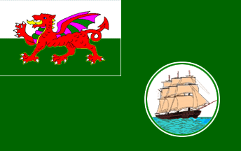
- Would the flag of Kemrese Guyana be simply that for Kemr, with the dragon etc.? Kyrmse 04:59, 2 Aug 2005 (PDT)
- Updated the map today. Comments and criticism welcome. Kyrmse 10:03, 5 Aug 2005 (PDT)
More Flags...
There are still some flags missing in the "long list" where each country is described in more detail. Maybe Jan could take care of that?! [In haste] Kyrmse 03:35, 28 October 2005 (PDT)
- At your service, sir! The only flag that is now missing is that of Kemrese Guyana, but I don't think there is one at the moment. --IJzeren Jan 03:56, 28 October 2005 (PDT)
- How about this, thats the badge (sort of) used *here* by british guyana during colonial times.--Marc Pasquin 09:41, 28 October 2005 (PDT)
I like it. But of course, the final word about this lies with Andrew. --IJzeren Jan 12:46, 29 October 2005 (PDT)
MISSING COUNTRY!
Nea Illenicia is missing! Per this article and related articles, it was supposed to be the sothern portion of Riu de l'Argent BoArthur 22:48, 20 January 2006 (PST)
Carlos' proposed borders are found here.
TAVORIA ???
I would advise reverting to the map in existence before Tavoria was proposed. Unfortunately I do not have a copy of it available. But some generous soul might do this. Kyrmse 10:37, 22 February 2007 (PST)
