Uploads by Benkarnell
From IBWiki
Jump to navigationJump to search
This special page shows all uploaded files.
| Date | Name | Thumbnail | Size | Description | Versions |
|---|---|---|---|---|---|
| 14:58, 25 November 2023 | AQ provinces.jpg (file) |  |
359 KB | Category:North American League | 1 |
| 15:53, 14 June 2023 | Langues de France.png (file) |  |
26 KB | Category:Maps of France | 1 |
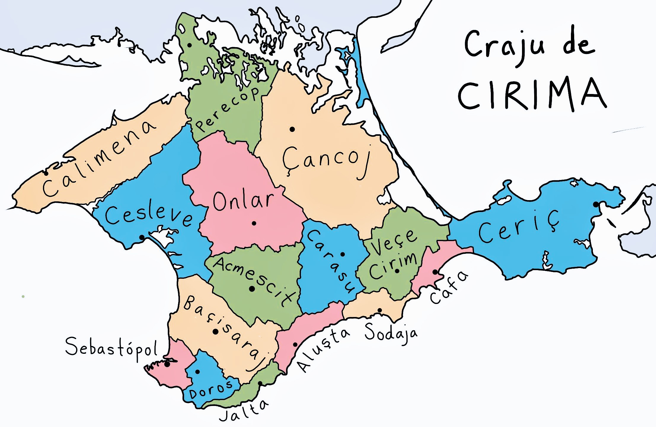
| 15:10, 20 September 2020 | Crajudecirima.jpg (file) |  |
358 KB | 2 | |
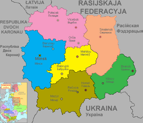
| 08:49, 20 September 2020 | Belarus map.jpg (file) |  |
65 KB | Map of Belarus by Pavel Iosad, brought here for safekeeping from http://www.cymraeg.ru/edricson/belarus.jpg Category:Maps of Europe | 1 |
| 14:11, 19 September 2020 | Crimeatamga.png (file) |  |
13 KB | Category:COAs Category:Crimea | 1 |
| 14:10, 19 September 2020 | CrimeaCOA.png (file) |  |
165 KB | Category:COAs Category:Crimea | 1 |
| 13:27, 29 June 2020 | Ib indonesia.jpg (file) |  |
362 KB | From http://cinduworld.tripod.com/seasia_in_ib.htm Here, then, is a tentative map of Indonesia/SE Asia as it might have appeared in the mid-17th Century. Category:South East Asia Category:Maps of Asia | 1 |
| 09:29, 3 May 2020 | IB world RS.png (file) |  |
126 KB | IB world map by Rebecca Stirling (alias Upvoteanthology, IB Member No. 85); [https://www.deviantart.com/upvoteanthology/art/Ill-Bethisad-552857836 originally posted here] Category:Maps of the World | 1 |
| 09:23, 3 May 2020 | Nal-slc-languages.png (file) |  |
32 KB | Map by User:Celeste Lavender, originally posted [https://www.alternatehistory.com/forum/threads/the-alphabetic-bouts-of-cartography-discussion-entries.252850/page-28#post-6885868 to alternatehistory.com] Category:Maps of North America | 1 |
| 05:15, 19 April 2020 | Danar.png (file) |  |
2 KB | Symbol of the Crimean danar Category:Currency | 1 |
| 07:40, 26 October 2019 | Benkarnell.jpg (file) |  |
44 KB | changes | 2 |
| 19:38, 25 October 2019 | Europe heads of state.png (file) |  |
138 KB | Corrections to MR and Hungary | 2 |
| 15:03, 19 November 2016 | Europe blank map2.png (file) | 95 KB | Minor corrections: more lakes, a few coasts, fixed the MR and a few other borders | 3 | |
| 13:07, 2 October 2016 | MapOfIB.png (file) |  |
857 KB | Category:Us | 1 |
| 17:29, 25 September 2016 | Europe reference map.png (file) |  |
208 KB | General map of Europe showing nations and major subdivisions. Category:Maps of Europe | 2 |
| 17:28, 25 September 2016 | Europe blank map1.png (file) | 95 KB | Grey map of Europe with white borders Category:Maps of Europe | 1 | |
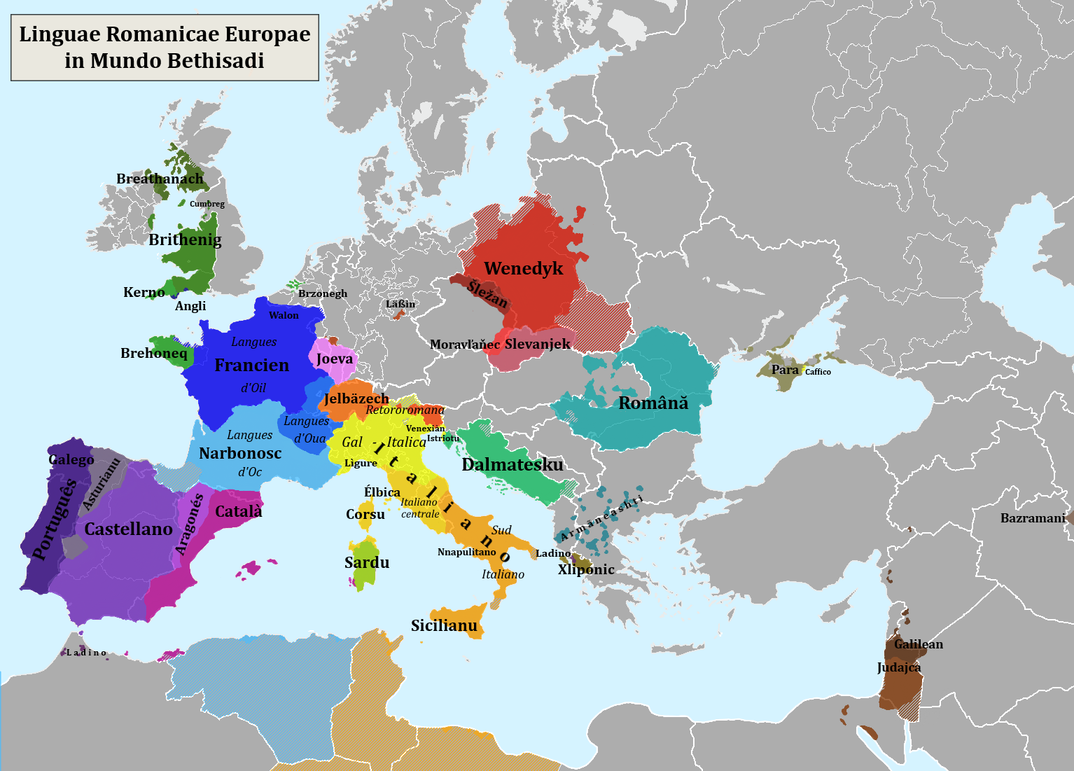
| 08:47, 15 August 2015 | Romance languages of Europe.png (file) |  |
331 KB | Remove last English labels, some small corrections to Bohemia & Czech speaking area of Lithuania | 3 |
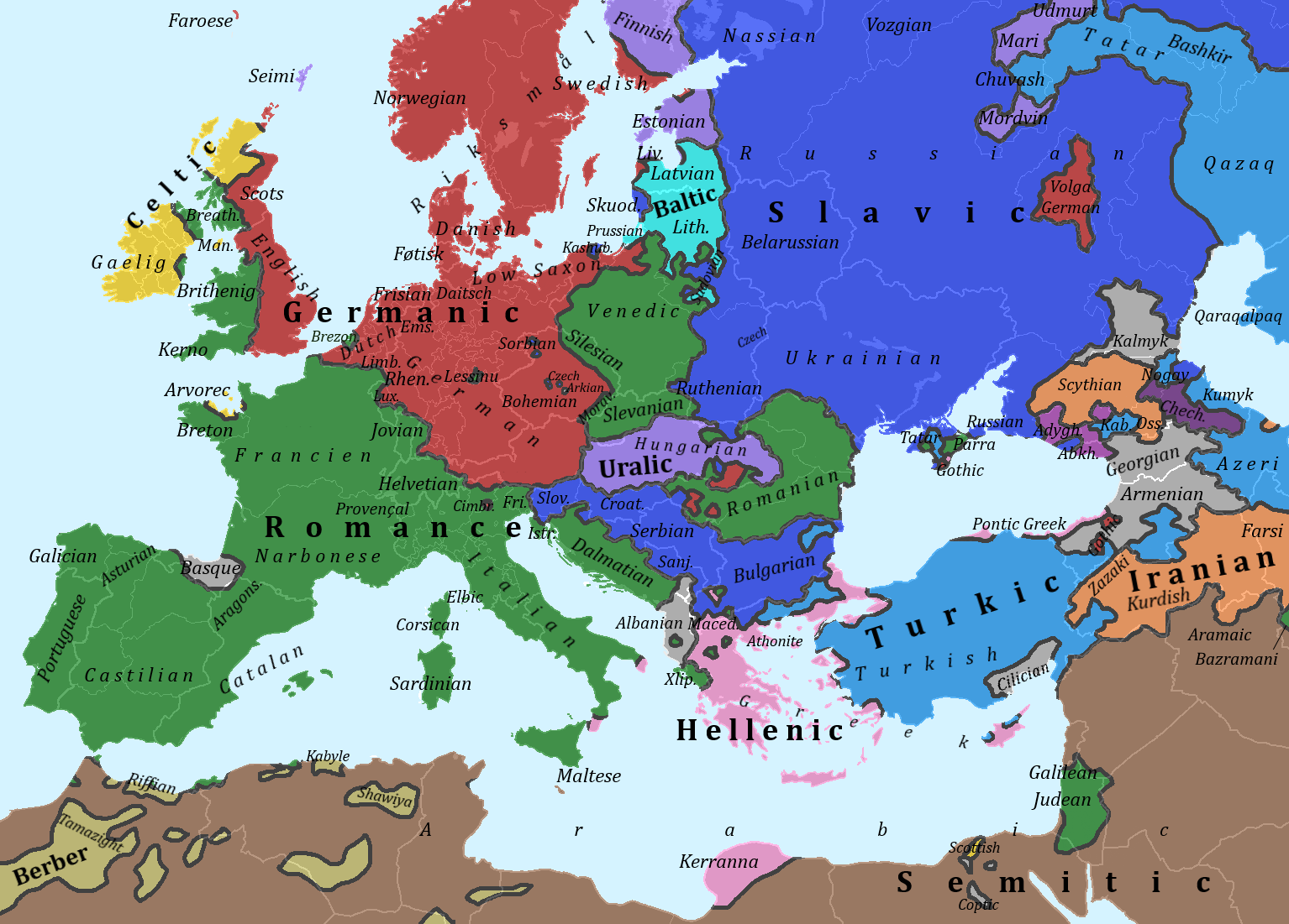
| 20:17, 13 August 2015 | Europe language families.png (file) |  |
389 KB | Corrections to Bohemia and Czech language | 5 |
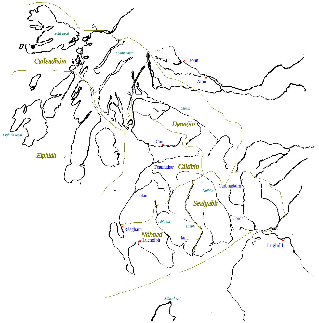
| 20:32, 26 March 2015 | Caileadhoin.PNG (file) |  |
72 KB | Category:Maps of the FK | 1 |
| 06:28, 24 March 2015 | 3Scotlands.jpeg (file) |  |
163 KB | 2 | |
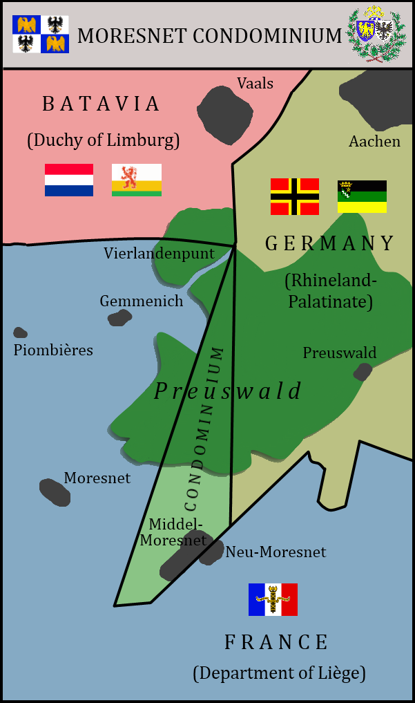
| 08:09, 23 March 2015 | Moresnet.png (file) |  |
120 KB | New flags for Moresnet and Limburg | 2 |
| 08:17, 22 March 2015 | Moresnet Flag.png (file) |  |
139 KB | Category:Flags of Europe Category:Flags of the HRE | 1 |
| 07:40, 8 March 2015 | European Federation.png (file) |  |
108 KB | Category:Maps of Europe Category:Currency | 1 |
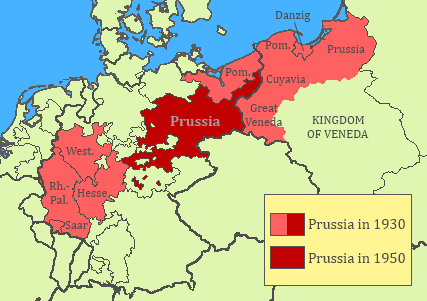
| 10:58, 21 April 2014 | Prussia losses.png (file) |  |
20 KB | 2 | |
| 11:59, 11 January 2014 | Western Isles.PNG (file) |  |
151 KB | Separated Cumberland from Yorkshire per old map. Add missing label for Derbyshire. | 4 |
| 23:36, 29 December 2012 | TauridanSovietRepublicProp.png (file) |  |
4 KB | Use Arabic script for Tatar, add Parra abbreviation. | 2 |
| 08:12, 21 May 2012 | Southern Department.jpg (file) |  |
40 KB | Archived from Hugo's old website, sent via email. Category:Ill Bethisad in Pictures | 1 |
| 08:11, 21 May 2012 | Northern Department.jpg (file) |  |
154 KB | Archived from Hugo's old website, sent via email. Category:Ill Bethisad in Pictures | 1 |
| 08:09, 21 May 2012 | Pitt the Younger.jpg (file) |  |
40 KB | Archived from Hugo's old website, sent via email Category:Portraits | 1 |
| 07:54, 21 May 2012 | Septimus.jpg (file) |  |
33 KB | Archived from Hugo's old website. Category:Portraits Category:Ontario | 1 |
| 07:46, 21 May 2012 | Vompire.jpg (file) |  |
26 KB | Archived from Hugo's old page, sent via email. Category:Aviation Category:Military Category:Australasia | 1 |
| 07:30, 21 May 2012 | AfricaEast.png (file) |  |
9 KB | Category:Maps of Africa | 1 |
| 07:30, 21 May 2012 | AfricaSouth.png (file) |  |
9 KB | Category:Maps of Africa | 1 |
| 07:29, 21 May 2012 | AfricaCentral.png (file) |  |
9 KB | Category:Maps of Africa | 1 |
| 07:29, 21 May 2012 | AfricaWest.png (file) |  |
9 KB | Category:Maps of Africa | 1 |
| 07:28, 21 May 2012 | AfricaNorth.png (file) |  |
9 KB | Category:Maps of Africa | 1 |
| 21:57, 28 April 2012 | Gallosphere.PNG (file) |  |
46 KB | Add Commonwealth island nations that speak French creoles. | 4 |
| 18:40, 18 April 2012 | Italia.PNG (file) |  |
30 KB | Move some borders to historical locations, especially Ceva, Modena & Parma | 5 |
| 19:55, 10 April 2012 | CrimeaCivil.png (file) |  |
2 KB | Category:Flags of Europe | 1 |
| 00:19, 4 December 2011 | Rapa-prop5.png (file) |  |
12 KB | 2 | |
| 05:40, 11 November 2011 | CrimeaNewFlag.png (file) |  |
10 KB | For heaven's sake, it was upside-down. | 5 |
| 21:44, 6 November 2011 | Thuringia.png (file) |  |
51 KB | 2 | |
| 21:44, 6 November 2011 | Weimar.png (file) |  |
23 KB | 2 | |
| 21:43, 6 November 2011 | Schwarzburg-sonderhausen.png (file) |  |
23 KB | 2 | |
| 21:43, 6 November 2011 | Schwarzburg-rudolstadt.png (file) |  |
25 KB | 2 | |
| 21:43, 6 November 2011 | Saxe-weimar-eisenach.png (file) |  |
24 KB | 2 | |
| 21:41, 6 November 2011 | Saxe-meiningen-hildburghausen.png (file) |  |
23 KB | 2 | |
| 21:37, 6 November 2011 | Saxe-gotha.png (file) |  |
24 KB | 2 | |
| 21:36, 6 November 2011 | Saxe-altenburg.png (file) |  |
24 KB | 2 | |
| 21:36, 6 November 2011 | Reuss-gera-greiz.png (file) |  |
23 KB | 2 |