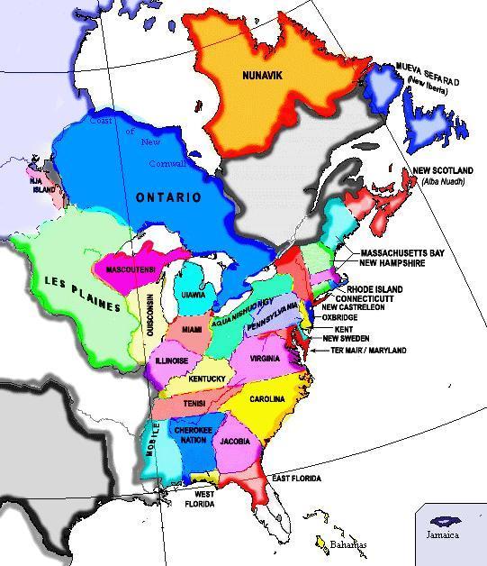
File talk:NAL map.gif
From IBWiki
Jump to navigationJump to search
For some reason, I thought that Mobile went only to the border of Tennessee here....Am I wrong? BoArthur
There's no Province of New England, either. *Here*'s Maine is part of Massachussettes, while *here*'s Vermont is part of New Hampshire Nik 09:37, 10 November 2005 (PST)
- Correct on both. You can even see the Mobile/Tennessee line in the present map! ;) "New England", like *here*, is a region of several provinces. *Here*'s Maine is part of Massacheussetts Bay (maybe we should just call it N.E., cos I can never spell Massachusetts right on the first go-round!). Elemtilas
- I based this on a map which I got from one of the websites. Since it is so wrong I'll happily nominate it for deletion. Might I suggest someone who is good at creating maps might want to have a go at what the borders of the NAL's various provinces actually are? Not a high priority, I should think, but useful. Zahir 10:31, 10 November 2005 (PST)
- Not so fast! A few errors can be corrected, can't they? Besides, it dóes look nice, this map, and I also agree that a map of the NAL provinces would be quite useful for us. The country surely is important enough for that! If you insist, I'll delete it, but I'd rather have a version with these two errors corrected. --IJzeren Jan 11:06, 10 November 2005 (PST)
- Okay. Can someone who knows what to do correct these? Zahir 11:45, 10 November 2005 (PST)
- Can you send me the file, my good Doctor? :) BoArthur
It's a fine map. There is absolutely no reason to delete the image. It needs only a couple minor corrections. [PB]
- All I did was fix a couple border issues and added New Hampshire and Jamaica to the picture. Elemtilas
- Many thanks. Zahir 22:38, 10 November 2005 (PST)
