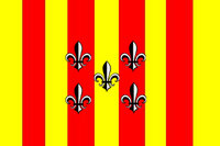
Nouvelle Gaulle

| |
| Motto: Liberté et Patrie' | |
| Subdivision of: | Louisianne |
| Cities: | |
| Capital: | Narbo |
| Largest: | Narbo |
| Other: | Tassin, Bergerac, Saint-Priest |
| Languages: | |
| Official: | Francien, Narbonosc |
| Others: | English |
| Préfet: | Benct Olaf Norbin |
| Area: | AREA |
| Population: | POPULATION ADJECTIVE |
| Established: | 1865, Decree of National Assembly |
The flatland along the coast of the Mizouri River. Nouvelle Gaulle is one of the quieter prefectures of Louisianne. Populated largely by Native American tribes, Nouvelle Gaulle does have some tension between farmers and Aboriginal Rights Groups who have successfully kept the North American Bison a free-range animal.
Administration
Government
Administrative Divisions
Nouvelle Gaulle is divided into three départements, Oto, Nyobrara and Omara.
History
Nouvelle Gaulle was created from the Préfecture du Nord in 1865 by act of the National Assembly. Nouvelle Gaulle received its name from the large number of settlers from the south of France. Dealing closely with the Native American inhabitants, the Neogaulois named the départements after the local tribes and the names of their geographical regions.
Geography
Borders
Nouvelle Gaulle is limited by:
- North: Nouvelle Navarre
- West: Nouvelle Cournouaille
- South: Osage
- East: Les Plaines, NAL-SLC
Economy
Culture
| |||
|---|---|---|---|
| Préfectures of Louisianne | |||
| Nouvelle Cournouaille | Nouvelle Gaulle | Nouvelle Navarre | Osage | Saint-Louis | Saint-Onge | |||
| Départements of Louisianne | |||
| Alpes-Argentés | Alpes-Rocheuses | Aurillac | Bretagne | Côte de Châtaigne | Côte d'Or | Daquota | Dordogne | Garonne-Neuve | Gascogne | La Salle | Les Ozarques | Loire-Neuf | Mississippi | Mizouri | Nyobrara | Omara | Oto | Paris-sur-Mizouri | Pays-Lointains | Pont-Chartrain | Rocheuses | Saint-Louis | Terre Platte |

