File talk:Europa wen.png
Stunningly beautiful. Can't comment on the Wenedyk, though. Benkarnell
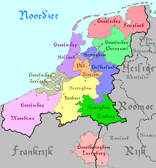
- I agree, this is just beautiful! My only problemn is the HRE-Francian border, what with us having just declared that Luxemburg is "Large Luxemburg" and not "Small Luxemburg". Seth 17:32, 27 August 2008 (UTC)
- Ok, it is not a problem, I've made it in .svg (scalable vector file format) so changes are easy. I was also wondering if put Luxembourg on the map, as you also agree that the state is almost fully independent as a part of HRE Follow by white rabbit 18:02, 27 August 2008 (UTC)
- All the HRE states are "almost fully independent;" Luxembourg just enjoys that a little more. It might be appropriate to write "Luxemburg" in Wenedyk in those small white letters. If there's not room for it, though, it is not a big deal. Benkarnell 19:26, 27 August 2008 (UTC)
Xliponia's northern border seems a touch off. BoArthur 18:45, 27 August 2008 (UTC)
- Thanks, BoArthur. It is indeed. Please see Geography of Xliponia. Kyrmse 20:01, 27 August 2008 (UTC)
I also just noticed that Grand Fenwick is not on the map... Seth 12:51, 31 August 2008 (UTC)
- Oh, and Armorica as well. Benkarnell 13:47, 31 August 2008 (UTC)
Any chance...
Any chance of an updated, English (*here*'s English, not *there*) version of this? Just wondering... Seth 04:44, 6 September 2008 (UTC)
- All of your suggestions will be realize in near future... just give me a bit more time, I'm also still waiting for Jan's opinion. Follow by white rabbit 09:17, 6 September 2008 (UTC)
- I'm still waiting for an English Version, but please take your time... You should also take the time to add in Armorica and Grand Fenwick. Oh, and Saugeas (?) Seth 02:01, 14 February 2009 (UTC)
- Also, I noted the areas that need to be added/modified... Hope you don't mind, here's my updated version. http://ib.frath.net/w/Image:Updated_europa.PNG
- NOTE - Grand Fenwick is larger on my map than it should be, as is (I think) Saugeas... Seth 03:10, 25 February 2009 (UTC)
Wow, this is awesome! How come I've never seen this map before???
In any case, I disagree with the proposed border change to the Batavian Kingdom. As can be seen here, the original borders were perfectly correct.
Furthermore, I suppose Luxemburg should indeed be added, but in a different colour. As it is part of the HRE, but seems to have some sort of status aparte there, another shade of brown might be in order (BTW, is it coincidence that the colour of Germany is brown? ;) )
As for the Wenedyk names, they generally look ok. I'd suggest a few minor changes, though:
- Edymbork > Edynbork
- Sammia > Samia
- Piotrogród i Nowogród > Piotrograd i Nowgorod
- Mutenia > Muntenia
- Dalmacja > Dałmacja
- Paź Basku > Paź Baski (or: Paź Baskór)
- Sieciogród > Sieciokościół (or: Trasylwania)
Furthermore, the capital of Ślewania is Kasowla (Košice), not Prota Ślewańka.
Aha, and don't forget to add the newly discovered Republika Monaścica.
That's all I can think of right now. Again, great work! —IJzeren Jan Uszkiełtu? 13:23, 25 February 2009 (UTC)
In reference to my called for map change for Batavia, see http://steen.free.fr/ib/maps/bataafs_koninkrijk.png which, I believe, that you yourself, Jan, told me were correct... Seth 02:33, 13 April 2009 (UTC)
Don't suppose you have a blank version? Would love to make an Emisc one! :) Geofism Tue 14 Apr 09 (AEST)
- Please do not forget the Xliponian border! Kyrmse 14:25, 15 April 2009 (UTC)