File:Western Isles.PNG

Original file (695 × 1,079 pixels, file size: 151 KB, MIME type: image/png)
Sources
- Coastlines: wikipedia:Image:Uk_map_england_green.png
- Ireland: Image:Ae-political-map.png
- Kemr: Image:Kemrprovinces.png
- Dumnonia: http://www.bethisad.com/map_kemr_2.jpg
- England: Image:EnglishCounties.gif
- France: Image:Fra-depts.jpg
- Scotland (Scots region): wikipedia:Image:ScotlandCountiesNumbered.png
- Scotland (Breathanach region): http://www.cix.co.uk/~morven/lang/caileadhoin.png
Legend
- Red lines: Between sovereign countries
- Orange lines: Between autonomous or self governing territories
- Brown lines: Between regions that are greater than basic administrative units but are not self governing
- Grey lines: Between basic administrative units
- Upright text: Self governing
- Italic text: Not self governing
Country by country explanation
Ireland: Since it's a federal state, I labeled the fifths as self governing units.
Scotland: Lots of QAA here. Since Scotland's a 3-language country I figured it would have some sort of offically recognized 3 regions, even if it's politically a unitary state; hence the brown lines. If it turns out that Scotland is federalized like Belgium or IB France, I can re-color them. The Scots-speaking counties are traced from a Wikipedia map. I basically postulated that while Scotland *there* kept its traditional county structure, it did reform its convoluted feudal boundaries in the late 19th century.
I didn't subdivide the Gaelic-speaking Highlands because their divisions are doubtless based on or descended from ancient clan territories. Assume that they're divided, although the map shows them as one unit. The only Gaelic county I labeled is Arcaibh, the Orkneys, which I assumed are a separate county. Shetland is in the little box, and it's not in italics because (1) it's not clarified whether it's self governing; and (2) italics didn't look good on the map.
England: Wight has a larger font and has a brown border to reflect its status as "the only indigenous group in England this side of the Hedge to have its own linguistic identity."
Kemr: Traced from a map on Kemr's talk page on the Wiki, with "Cumria" replaced with "Rheged" per the discussion there. Lundy is a self-governing entity within Dumnonia.
Hay-on-Wye: It's in the same place as the real-life village. I made it very small, but its size and I guess location are QAA.
Armorica: Confederated into Ceasaer and Saern, with the other inhabited isles labeled as administrative units.
France: The mostly ceremonial provinces are shown with brown lines but not labeled. According to this map, Loire-Atlantique seems to be part of the ceremonial province of Brittany, but not part of the Duchy of Brehun, shown as being federated because of its unusual status.
Flags: All the entities on the map that could qualify as "nations" and have a defined flag are up there. They are: Ireland, Scotland, Kemr, England, Hay-on-Wye, Dumnonia, Armorica, Wight, Brittany, and France. Brittany and Hay-on-Wye come from FOIB; Wight comes from Damon's website; the rest come from the Wiki. FOIB also has a flag for Francy, which I skipped in lieu of the flag of France.
Notes from Conculture
Padraic: About the border between England and Dunein -- I've never actually "set" where the border should be, though I note you've got a few extra bumps where the original map has a smoother border. About all I can say is that the border is east of the Avon River and east of the A-338 / Salisbury Road. One of these days, I'll have to sort it out.
Ben: That border is sort of a compromise between the England map and the Kemr map. The England map shows the bumps.
Original discussion: 30565
File history
Click on a date/time to view the file as it appeared at that time.
| Date/Time | Thumbnail | Dimensions | User | Comment | |
|---|---|---|---|---|---|
| current | 10:59, 11 January 2014 | | 695 × 1,079 (151 KB) | Benkarnell (talk | contribs) | Separated Cumberland from Yorkshire per old map. Add missing label for Derbyshire. |
| 13:11, 21 August 2009 | 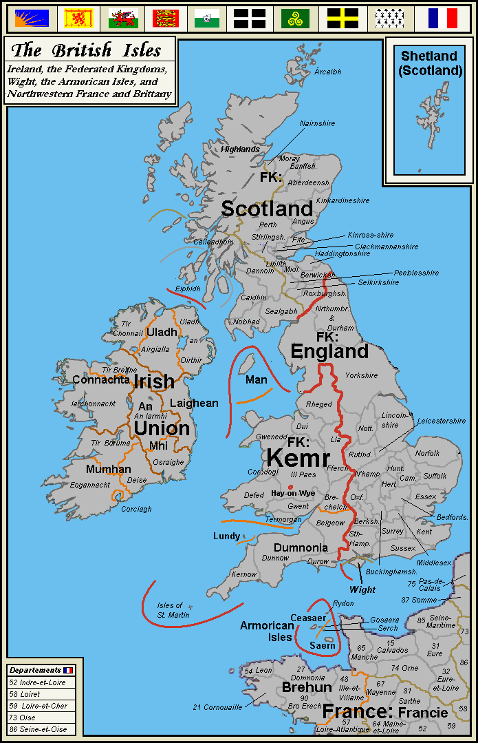 | 695 × 1,079 (111 KB) | Benkarnell (talk | contribs) | Fixed Ireland, title | |
| 13:52, 2 July 2008 |  | 695 × 1,079 (111 KB) | Benkarnell (talk | contribs) | Correct I. St. Martin font size; spelling of Francie | |
| 20:09, 26 June 2008 |  | 695 × 1,079 (111 KB) | Benkarnell (talk | contribs) | Category:Maps of the Federated Kingdoms |
You cannot overwrite this file.
File usage
The following page uses this file: