Charcas
From IBWiki
Jump to navigationJump to search
| File:?map.PNG map of the ? | |
| Motto | ? ? |
| National Anthem | ? |
| Cities | |
| Capital | Villa Serrano 19°06'60"N 64°19'60"E |
| Government | Tribal council |
| Head of State and Government | Antonio Quispe |
| Demonym | Charca |
| Formation | |
| Autonomy | June 15, 1852 |
| Area | 2,000 km² 772 mi² |
| Population | 9, 489 (2015) |
| Ethnicities - Citizens | Charcas 98% Other 2% |
| Languages | |
| Official | Aymara |
| Other | Guaraní |
| Religions | |
| Official | Pachamama worship |
| Others | Buddhism |
| Currency | 1 Sol ($) = 20 reales (R) = 240 centavos (¢) |
| Time zone | UTC -4 |
| Telephone Code | 7366 |
| Sports | |
| Official | Tlachtli (updated!) |
History
- The Charcas are an Aymara-speaking people who live in the easternmost part of Tawantinsuyu, in *here's* Chuquisaca Department of Bolivia. They frequently suffered from incusions of the Chiriguanos who lived in *here's* southeastern Bolivia. The Inka Empire, under the Sapu Inka Wayna Qhápaq (1493-1527), conquered the Charcas, as part of the southern expansion of the Empire before the arrival of the Spanish.
- They were in turn, subjugated by the Spanish. The first conquistador to make contact with the Charcas was the Portuguese Aleixo Garcia in 1535.
- After the Inka Empire regained its independence in 1835, the Charcas rebelled and attempted to establish their own sovereign nation. Aided now by the Chiriguanos, who had fled into IB Paraguay upon the arrival of the Spanish, the Charcas resisted the Empire for four years.
- Only upon promises of autonomy given by the Sapu Inka Manku Qhápaq II (1835-58) did they cease hostilities. They entered into a treaty with the Empire that granted them autonomy. However, autonomous status was not able to be given to their homeland because the city of Ciudad de la Plata de la Nueva Toledo (*here's* Sucre) had been founded in their homeland by the Spanish in 1538 and had become a major metropolitan center. Upon the independence of the Empire the city was renamed Chuquisaca.
- They were given a choice of homelands (limited, to be sure) and decided on the *here's* province of Belisario Boeto farther east on the border with (IB) Paraguay, which they renamed Charcas. It was sparsely populated and any inhabitants who did not want to remain in the district were given homes elsewhere.
Politics
Administrative divisions
- This division of Antisuyu province is known as a Comarca Indígena.
- The Comarca is divided into six Communes (comuna).
- In the Comarca are one town (pueblo), Villa Serrano, the seat of government, and 24 villages (aldea).
Government
- The autonomous region is to remain permanently neutral and demilitarized.
- The region determines its own internal affairs, but the Empire is responsible for defense and foreign relations.
- It has its own government with a Tribal Council composed of 25 elected deputies, elected by universal suffrage for a four-year term. The town and each village send one deputy to the Tribal Council.
- The executive officers of the Tribal Council are a Chief and a Deputy Chief (elected at large) and six secretaries who are responsible for day-to-day operations of the six municipalities. The secretaries are appointed by the tribal council from among the citizens of their respective municipalities.
- The Charcas have full citizenship in the Empire.
- The Charcas may travel freely into the Empire, but may not work therein.
- The Charcas may not cross the border into Paraguai.
- The Charcas maintain their own police force with help from the provincial government as needed.
- The Comarca sends one representative to the provincial legislature.
- The judicial branch of the government consists of courts of the first instance. Appeals are handled by the provincial courts.
- Judges are appointed by the tribal council with the approval of the provincial court.
Culture
Religion
- The religion of the Charcas is the cult of Pachamama.
Education
- Education is carried out in the Aymara language.
Symbols
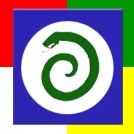
- The flag of Charcas is blue with a solid white circle in the center. On the white circle is a green serpent in a spiral. There is a border around the blue which is divided into four parts, green, red, white and yellow. The blazon is: Azure, a roundel White charged with a serpent involved Vert, a bordure quarterly Vert, Rouge, Argent and Or.
- The meaning: The white roundel is the moon. It, the serpent and the spiral are symbols of Pachamama. The border quarterly makes it look like the flag is placed on top of the flag of the Empire symboliziing that the comarca is protected by the Empire.
Borders
- Charca is bounded by
- on the north: Tawantinsuyu
- on the west: Tawantinsuyu
- on the south: Tawantinsuyu
- on the east: Paraguay
- on the north: Tawantinsuyu
